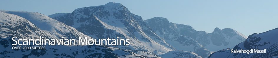
Scandinavian Mountains over 2000 metres - James Baxter
Areas › Kalvehøgdi Massif › Kalvehøgdi › Alternative Routes
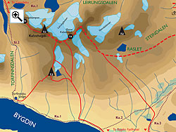
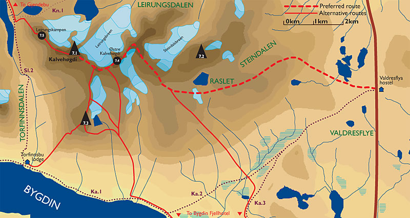
There are a few routes up Kalvehøgdi.
- There is the main route up from Valdresflye. This is an excellent route in the summer on foot and in the winter/spring on skis. This route is described on the main page.
- There is the route which is similar to the main route above route but starting from Bygdin Fjellhotel lodge. This route itself has 2 variations. Either via Søre Kalveholotind or via Nordre Kalveholotind.
- There is the the shorter route from Torfinnsbu lodge via Nordre Kalveholotind. There is some easy scrambling involved in climbing Nordre Kalveholotind.
- There is the trickier route from Svartdalsbandet at the top of the huge Leirungsdalen valley which goes over the alpine peak of Leirungskampen. This involves abseiling down a 15 metre grade III crag south east of Leirungskampen and some further scrambling up the sharp west ridge of Kalvehøgdi.
 From Bygdin Fjellhotel lodge
The route from Bygdin Fjellhotel lodge either goes via Søre Kalveholotind or Nordre Kalveholotind. The first route is a long route in the summer, but is a superb route in the winter/spring when the road to Bygdin is open but the road further up the hill over Valdresflye plateau is still closed. Either go walk or ski along the locked track for 3 km on the path Ka.1 to the ramshackle and abandoned Bygdisheim lodge. Leave path Ka.1 just after the building and now head north traversing up the gentle hillside on path Ka.3 for another 3 km. Leave the path here and head across the flat valley floor keeping well north of the small tarn with the island. The terrain here is marshy with the odd willow thicket to bash through. In the winter/spring however it is easy to cross this valley. Make for the ridge between the two valleys containing the Repefonnbekken streams crossing the marked Ka.2 path. Follow this ridge up for 1½ hours until you reach the top at 1844m. From this top head up the west side of the slope up to top 2088 meters, Mugna, Østre and Midtre Kalvehøgdi and then the summit as described on the main route page. This route is best as a ski route.
 The route from Bygdin Fjellhotel lodge to Kalvehøgdi via Nordre Kalveholotind also goes via the ramshackle Bygdisheim lodge on path Ka.1.It is suited for either a summer foot tour or a winter/spring ski tour for more experienced skiers. Continue along the shore for another 2 hours or 6 km crossing a small stream by a bridge until you get to the buildings at Hestevollen. Just beyond this is another small bridge over the Hestevollåne stream. Cross this bridge and leave the path heading up the slopes to the west of the stream. After about an hour the terrain steepens and forms into a broad ridge. Head up this ridge veering north west for another hour until you are in a large bowl beside the lake at 1745m which lies beneath the large cliffs on the east side of Nordre Kalveholotind. The final slopes before you enter this bowl are steep you will probably have to remove skis in winter. Once in the bowl you have a choice of three routes depending on the season.
- During the summer scramble up the easy grade I south east ridge to the summit of Nordre Kalveholotind. From this summit head north down through the saddle to Midtre Kalvehøgdi and then Kalvehøgdi itself.
- During the winter/spring it is feasible to ski up the marginally crevassed western Kalveholobreen glacier to the saddle between between Nordre Kalveholotind and Midtre Kalvehøgdi. There might be a cornice to overcome as you approach the saddle. From the saddle proceed as above.
- During the summer or winter/spring it is possible to continue north up the ridge to the main ridge and the edge of the escarpment reaching it just south of Østre Kalvehøgdi. Once on the main ridge at Østre Kalvehøgdi follow the main route to the summit.
The route over Søre Kalveholotind or the three variants of the route over Nordre Kalveholotind are long and you should allow 8-10 hours. Any of the routes can be used as a descent route except for the route down the south east ridge of Nordre Kalveholotind.
Via Nordre Kalveholotind from Torfinnsbu lodge
Climb Nordre Kalveholotind from Torfinnsbu lodge as described on the Nordre Kalveholotind page. This ascent involves some easy scrambling up a gully in the summer but there is a band of steep and sometimes wet vegetation and slabby outcrop to pass below the gully making route finding tricky. In the winter/spring this face and gully is steep and winter climbing experience is essential.
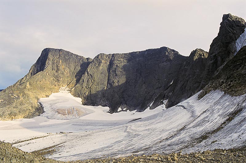
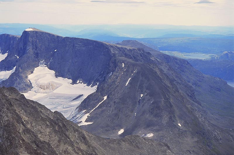
 From the bouldery summit of Nordre Kalveholotind head north across boulders down a gentle slope to a saddle. To the west of this saddle is a high shallow bowl with a lip beyond which it drops off very steeply down to Torfinnsdalen. While to the east of the saddle the the relatively gentle Vestre Kalveholobreen glacier. From this saddle continue north for a good ½ hour up the south ridge of Midtre Kalvehøgdi. As you ascent the stony slope the gentle slopes down to the bowl continue on the west but on the east the glacier has carved a corrie and a line of cliffs gradually increases. When you reach Midtre Kalvehøgdi a splendid view is suddenly revealed down the huge cliffs to the glaciers below and the alpine Knutshols-Tjønnhols massif beyond it.
From the rounded summit of Midtre Kalvehøgdi head up the south east ridge of Kalvehøgdi along the edge of the escarpment for a km passing through a small saddle before beginning the easy and very scenic climb up to the summit.
The return could be by the same route in which case allow 6-7 hours from Torfinnsbu lodge. Alternatively return by the main ascent route to Valdresflye allowing 7-9 hours in total. It is also possible to descent via Leirungskampen but this is much more demanding as described below.
Via Leirungskampen
The route up Leirungskampen goes via its north west ridge from Svartdalsbandet. To reach Svartdalsbandet from either Torfinnsbu or Gjendebu lodges take the path Sl.2 in the relevant direction for 2-3 hours until you reach the junction with the path Kn.1. Then take this fork up the steep his fork up the steep hillside on the south side of the cascading beck for ½ hour until you reach the upper Leriungstjønnin lake, which is a watershed.
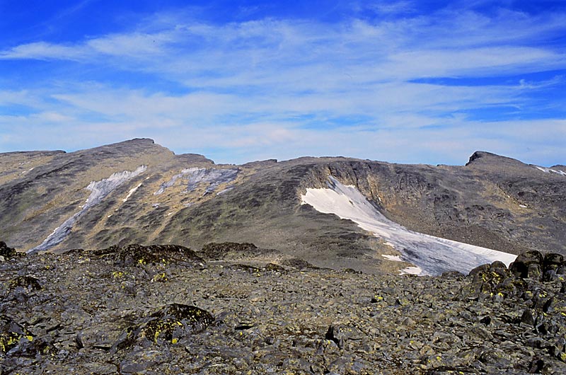
 The north west ridge of Leirungskampen starts immediately at the slabby outflow of this lake. Initially the going up is easy but this is short lived and the rest of the ridge is a clamber up steep boulders for almost an hour until the terrain levels off. As a consolation for the slog the already splendid view gets even better as you gain height. At the top of this bouldery ridge the terrain levels off as you reach a flat stony plateau. This plateau seems to slope gently up to the summit. However, between here and the summit is a jagged saddle with a small sharp peak in the middle of it.
Saunter across the pleasant plateau for 300 metres to the south east side when suddenly the saddle appears.To the north of the plateau is a tremendous cliff down to Leirungsdalen valley far below and to the south are very steep and loose crags down to Torfinnsdalen valley. The route of the plateau down to the saddle is very steep for about 20 metres. It is easiest to head down the south west side for 5 metres before the descent, which is loose and somewhat airy but is just an easy grade II scramble at the most. In the notch between the plateau and the small angular peak in the saddle you can decide to go over or round the angular peak. The short ascent is easy but the top of the descent on the south side is initially very steep for 5 metres. It is still no more than a grade II scramble. If you contour round the west side of this small peak it is across steep loose scree. At the notch on the south side of the small angular peak in the saddle is a steep ice filled gully which disappears down steeply to the glacier far below.
Once at the notch on the south side of the angular peak there is an an easy clamber up rocks to the summit which is situated on the north west side of a much small plateau. The continuation from here along down the ridge to the saddle with Kalvehøgdi is now very steep and needs to be abseiled. The total height of the crag is 40 metres but there are numerous scree covered shelves from which to break the abseil, so a 50 metre rope is easily suffice. If coming in the other direction the climbing from shelf to shelf is up to grade III.
This crag however can be avoided by traversing round the steep scree covered west face of Leirungskampen. To make this steep traverse return to the southern notch in the saddle. That is the notch between the angular peak and the summit. From this notch start to traverse down on the west side of the summit across steep scree. When you are well past the summit start to clamber up to reach the arête below the 40 metre crag.
Scramble along the arête avoiding any obstacles by traversing across the steep south west side for 200 metres until you reach the foot of the steep arête which leads up to Kalvehøgdi. This arête is steep and often exposed and involves numerous scrambling sections up to grade III. However most of these can be avoided on the south west flank of the arête across steep scree and slabs. The descent of this ridge will be more problematic as it is not easy to pick a route.
Once at the top of the arête the steep slopes to the south west down to Torfinnsdalen valley disappears as you gain a sloping plateau. However on the north side the huge cliffs along the escarpments edge continues. Follow the escarpments edge up a shallow stony slope for ¼ hour until you reach the summit. This route from Svartdalsbandet takes 3-5 hours. If going in the opposite direction allow the same.
Return by either the main ascent route to Valdresflye and the east or via the alternative route over Nordre Kalveholotind to Torfinnsbu lodge.