Scandinavian Mountains over 2000 metres - James Baxter
Areas › Uranos Massif › 3.4 Langeskavlstind (2014m)
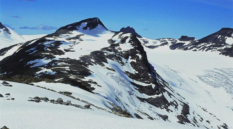
Langeskavlstind, 2014m, is a long wedge-shaped mountain. The long undulating ridge along the top of the wedge is mostly of a shallow gradient with only a couple of slightly steeper sections which are still shallow enough to allow a ski ascent in the spring. The ascent up the ridge goes from the comfortable periphery of Jotunheimen into the wild and very spectacular heart of it with the minimum of effort. As such, it is one of the great mountains to have as an introduction to climbing the 2000 metre peaks, and the views, especially towards Hurrungane are fantastic.
| The Route from Fondsbu Lodge | |
|---|---|
      |
|
Leave the car park by Fondsbu lodge and return back up the road to Tyinholmen for 800 metres until you reach the cairn and the signpost indicating the start of the track to Skogadalsbøen lodge. Leave the road here and follow the marked path up through the cabins on the southwest side of the Sløtabekken stream for two km until you reach the Sløtatjønet lake.
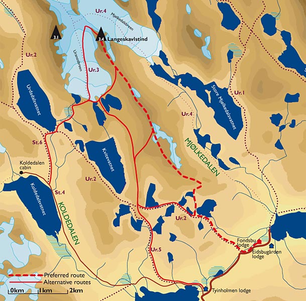 Continue along the south side of this lake and then turn north up the west side of it towards a bowl. The route onto the ridge goes up the east side of this bowl in an obvious, but steep valley, to reach the ridge in the saddle between the knolls marked 1483m and 1552m.
Despite leading in the wrong direction this gully is the only feasible option for a spring ascent on skis up this bowl.
Once the ridge is gained at the top of this bowl the route is quite straightforward and follows the crest of the gentle ridge in a north west direction for a further seven km.
During this pleasant stroll there are superb views which continually unfold and improve. Initially the route undulates over knoll 1552m for a km then arrives at the bottom of a sustained ascent of 200 metres over a half km.
This ascent will be no problem in summer, but in spring will test the ski skins grip until knoll 1740m is reached. From knoll 1740m there is an extremely agreeable four km saunter along the rolling ridge over a couple of gentle knolls and the false top of Langeskavlen, 1878m, and onwards to the saddle between Langeskavlen and Langeskavlstind.
During this four km saunter along the ridge care must be taken, especially in spring and early summer, not to venture to far to the east, as a enormous cornice sits on top of a steep drop along nearly the entire length.
 From the saddle, marked as 1752m, there is a further 260m metres to climb over 1½ km to the summit. This final ascent is not demanding in summer on foot or spring on skis.
From the summit there is a stunning view of the Styggedals ridge from Gjertvasstind to Store Skagastølstind in Hurrungane framed, aptly, between Slingsbytind and Uranostind.
There is also a sobering view down onto the subtle, but deep, crevasses in the glaciers on each side, namely, Uranosbreen and Mjølkedalsbreen, which should be enough to discourage un-roped glacier travel! The return is by the same route or one of the alternatives mentioned above.
