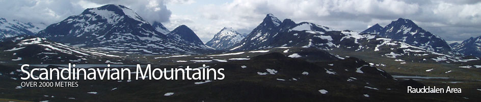
Scandinavian Mountains over 2000 metres - James Baxter
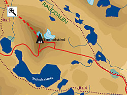
Areas › Rauddalen Area › Snøholstind › Alternative Routes
There are four routes up Snøholstind. One up the north west and east arêtes and also one up each of the west and east flanks to points high on the southern arête. The classic and possibly the most enjoyable route, with some interesting scrambling, is up the north west ridge from Olavsbu cabin.
The route up the east arête involves some climbing and very exposed scrambling. The route up east and west flanks involve some scrambling or sttep snowfields also.
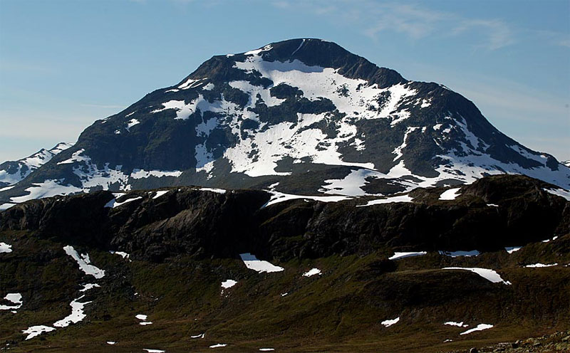 I have described the classic north west ridge from Olavsbu cabin as the preferred main route and the other four I describe here as alternatives.
West Face Route
The route up the west face starts at Fondsbu lodge and follows the marked path, Ur.1, for 2 hours until the path gets to a junction. At this junction take the marked fork, Ra.5, which continues north to Olavsbu cabin, down the north side of the pass for ¼ hour to reach the shore of Øvre Snøholsvatnet lake.
Go round the south side of this lake to the outflow. Jump the stream and start to climb up the sparsely vegetated slope towards the summit. Keep heading north up bare rocks and slabs for a short ½ hour before starting to veer east onto a large sloping scree covered shelf.
Continue up this sloping stony shelf for another ½ hour as it curves round to the south east to reach a prow at 1820 metres above a 200 metre crag. From this prow the route now heads up across more boulders and stones to a saddle between the ridge and the small knoll 1922m on the apex of the south ridge proper.
From the saddle clamber up stones to the bottom of a 50 metre outcrop. This outcrop is steep and airy, but the scrambling it is not that demanding at grade II. The easiest line is just to the east side of the apex up slabs and corners within a larger ill-defined gully. Once this outcrop is climbed you gain the flat summit plateau. Head across north across the flat plateau for ½ km to reach the summit cairn.
Return by the same route allowing 8-10 hours back to Fondsbu lodge or return down the north west ridge to Olavsbu cabin allowing 7-9 hours.
 East Face Route
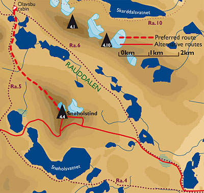
The route up the east face is best started at Gjendebu lodge by following the marked path Ra.3 and then taking the fork Ra.4 soon followed by fork Ra.6, which is the paths one would take if following the marked paths from Gjendebu lodge to Olavsbu cabin.
After 3-3½ hours you reach the lake 1424m at the start of the Rauddalen valley. Leave the path here and start to head due west across the stony tundra passing a few tarns as you make for the steep corrie on the east side of Snøholstind.
As you enter the corrie the terrain becomes more bouldery and the vegetation disappears. Once in the corrie there is a short hours slog up boulders between outcrops towards the cliffs high up above you on the top of the east ridge.
Once past the outcrops, halfway towards the cliff at the top of the slope, you enter a shallow basin usually filled with snow in the first half of summer. Veer south west now and traverse up these snowfields under the line of cliffs and the summit plateau to reach a section under the south ridge.
As you approach the top of this traverse you reach the foot of a steeper 40-45 degree snowfield which has to be climbed to gain the southern part of the summit plateau 50 meters higher up. This steep snowfield could be icy and is the crux of the route. As the summer progresses this snowfield becomes smaller and boulders appear.
 Once the summit plateau has been gained head north for ½ km to reach the cairn.
Descend by the north west ridge to Olavsbu cabin allowing 8-10 hours for the whole tour or by the west flank to Fondsbu lodge allowing 10-12 hours for the whole trip.
East Ridge Route
The third alternative route is the difficult east ridge which involves climbing up to grade IV. Start in Gjendebu lodge and follow the route as described above into the eastern corrie.
Alternatively it is feasible to start at Fondsbu lodge and follow the path Ra.11 for 2 hours until you reach and jump or wade the sometimes difficult Høystakka stream. Leave this path here and head north across the tundra for another 1½ hours to the eastern corrie.
If coming from Olavsbu cabin follow the path Ra.6 for an easy 2 hours the head south around the foot of the east ridge to reach the eastern corrie. Once in the eastern corrie climb up the boulders between the outcrops until you reach a higher basin. Continue northwards up this basin through massive boulders to a very small saddle on the east ridge.
This saddle, at about 1935 metres, on the ridge is where the climbing starts. There are 5 pitches all together which takes about 1½ hours to climb. The last two are the most difficult. The penultimate pitch involves a traverse over a very narrow and exposed edge which is grade III for 25m where a long sling is needed.
The final pitch is also 25m and goes up a grade IV corner on the south side of the ridge. At the top of this final pitch the arête is still sharp for another 5 minutes before it opens out onto a boulder covered ridge. Follow this broader ridge up for ¼ hour until you reach the summit plateau.
Head west across this stony area for another ¼ hour until you reach the cairn.