Scandinavian Mountains over 2000 metres - James Baxter
Areas › Uranos Massif › 3.2 Mjølkedalspiggen (2040m)
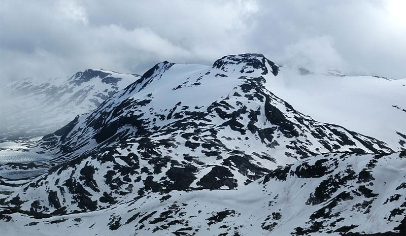
Mjølkedalspiggen, 2040m, lies to the north east of the Uranos massif and is one of the more remote mountains in Jotunheimen. On its south side is Mjølkedalsbreen glacier, a large and heavily crevassed glacier which has carved a deep ice filled valley. On the north side is the reasonably isolated Skogadalen valley. It is from this valley that the easiest routes to the summit start.
| The Route from Fondsbu Hotel | |
|---|---|
      |
|
This route up Mjølkedalspiggen is the longest of the 4 routes, but it is the simplest and the easiest to do alone, as it does not involve any glacier travel or scrambling. The route starts at Fondsbu lodge but an alternative starting point could be Olavsbu cabin.
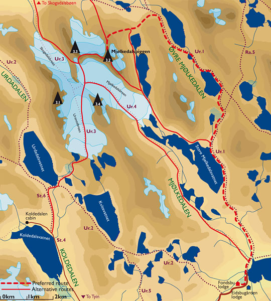 From Fondsbu lodge head north on the path Ur.1 which goes to Skogadalsbøen lodge. Head north for about 2½ hours passing Mjølkedalsvatnet lake until you reach a junction to the east of the steep face of Storegut, 1968m. Do not continue to Olavsbu cabin over a small saddle, but take the west fork down into the entrance of a deep U- valley whose floor is filled with a series of lakes, the Mjølkedalstjørni.
Head north west into this valley, called Øvre Mjølkedalen, following the rocky northern shore of first lake to the outflow. Continue into the deepening valley across pleasant grassy terrain passing a tarn before you cross over the stream to the west side of the valley before coming to a larger lake.
The steep slopes of the majestic Mjølkedalstind rise steeply to the east of this lake. Continue to the north end of the lake where there is a pleasant grassy plain and a great view down Skogadalen unfolds. This is a good camping spot if the return trip from Fondsbu lodge is considered too long.
At this grassy plain the route now leaves the valley paths and starts to climb the mountain itself. Contour up round the long north ridge which descends from Storegut heading south west to a stony saddle.
 Just to the south of this saddle is the upper of the Øvre Mjølkedalsvatnet lakes. The shallow north east ridge leads up from this saddle. Head up it for a good ½ hour across stones and boulders until it almost levels off. Continue up this flatter section for another ½ hour until the ridge becomes bare with rock outcrops and steepens.
Weave through these outcrops to the south of the small glacier on the east flank for another good ½ hour to reach another smaller flat area where the glacier on the north and east sides almost meet. This flat area is at the base of the summit crown. From here it is a simple clamber up over boulders for a short ½ hour to reach the summit.
The return is by the same route unless you have glacial experience or want to scramble down the south east ridge. Alternatively if you have decided to camp in Skogadalen it is very feasible to include an ascent of the southern summit of Sagi as it is only 2-3 hours return from Mjølkedalspiggen.
It is also possible to return directly to Skogadalen valley from Sagi; for further details see the Sagi page.
