Scandinavian Mountains over 2000 metres - James Baxter
Areas › Rondane › 17.3 Høgronden (2114m)
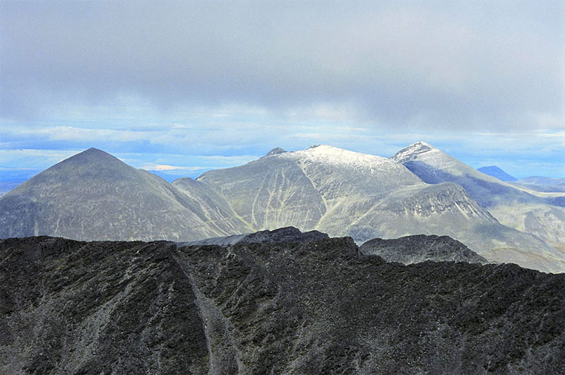
Høgronden, 2114 metres, is also a conical mountain which lies at the west end of a massif with another two mountains. Høgronden is the highest of the three mountains in this rounded massif and is connected to the other two by a rocky undulating ridge only has one short scrambling section. Høgronden is accessible from most directions, however there are two corries on the north side which are very steep. Between these corries is the north ridge which allows an easy route of ascent.
| The Route from Dørålseter Lodge | |
|---|---|
      |
|
Leave Dørålseter on the marked path to Rondvassbu. After about 800m the path divides and you want to take the southern branch which soon crosses the Døråi River over an all year bridge. Continue along the river for just another 300 metres under a steep terrace until there is another signposted fork. At this fork take the branch which goes straight up the steep sandy bank.
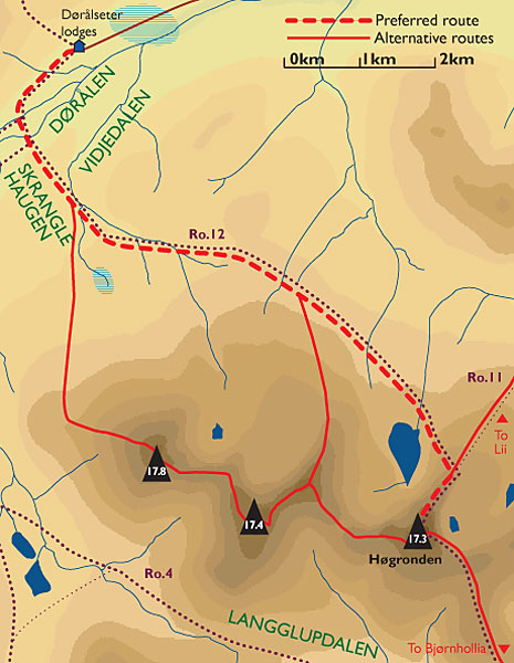 Once on the top of this bank the path weaves through an unusual post glacial landscape, Skranglehaugan, a square km of small craters and hollows, some filled with water. After a ½ km of weaving through this remarkable landscape the path meets a stream, Vidjedalsbekken.
Follow the marked path along the south bank of the Vidjedalsbekken stream for one km until it crosses to the northern bank. The path only follows the north bank for ½ km before it veers away from the stream and across packed lichen covered stones for a km to reach a small tarn, Neverbutjørni.
Pass along the south shore of this lake and follow the path as it sidles across the gentle stony lichen slope for 3½ km in south east direction.
After an easy hour the path gently climbs and crosses a second and larger stream emerging out of Midtbotn corrie. Cross the stream, which is the last available water for a while, and start to head up the steeper scree covered slope for ½ hour to reach the crest of the north ridge.
 Once on the north ridge follow the well marked path, which narrows into some interesting sections but is never exposed. After a long 3/4 hour the path eventually reaches the summit and a spectacular view over Rondslottet suddenly unfolds.
The return is either by the same route by continuing along the marked path down the south side of the mountain to Bjørnhollia or Straumbu lodges as described above. It is also possible to return to Dørålseter by traversing the entire massif over the mountains of Midtronden and Digerronden which should take about 6 hours from here and only involves a small section of easy scrambling. See the Midtronden page for more details of this traverse.
