Scandinavian Mountains over 2000 metres - James Baxter
Areas › Sjødalen › 12.1 Nautgardstind (2258m)
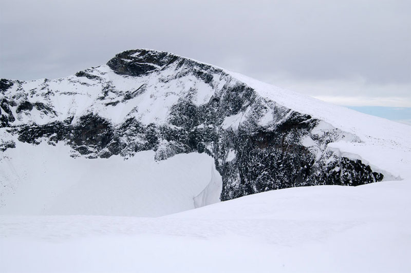
Nautgardstind, 2258m, when seen from the south is a fine cone shaped hill whose qualities were exalted in books written in the 19 century. Three sides of the mountain are comprised of relatively gentle slopes yet on the north side of the mountain are deep corries encircled by precipitous faces.
| The Route from Glitterheim Lodge | |
|---|---|
      |
|
From Glitterheim lodge head east and follow the marked path to Gjendesheim/Bessheim lodges. After a km the path crosses the Veo river over a summer only bridge and continues east for another two km across flat scrub vegetation towards the lower end of the ravine through which the Søre Åe stream tumbles. At the bottom of the ravine the marked path heads south up the slope to gain the top of the bank on the west side of the ravine.
 After the short initial climb the gradient eases considerably and the path continues up a pleasant slope with unfolding views for two km crossing over the infant Søre Åe stream. About ½ km after crossing the stream leave the marked path, which continues up the valley to a saddle, marked 1731m, one km further south. After leaving the path start heading up the gentle scree covered slope to the south east. The slope although gentle is surprisingly long and it takes well over ½ hour to reach the rounded peak of Nautgardsoksle. Only just before reaching this peak does the summit of Nautgardstind comes into view.
From Nautgardsoksle the route follows the rim of the corrie across large scree for a good ½ hour down to a saddle and then up the final boulder covered slopes to the summit of Nautgardstind. During the spring, the rim of this corrie sports some huge cornices and a respectful distance should be maintained to avoid plunging through them, especially in poor weather. The last section up to the peak usually has a poor covering of snow in the spring and it is often necessary to remove skis during a spring ascent. There is reasonably impressive view from the top down to the forests and lakes of Sjødalen and beyond while in the other direction (to the west) is row upon row of jagged peaks as most of Jotunheimen is on display.
The simplest and easiest return is by the same route. It is also very feasible to continue to Bessheim or Gjendesheim lodges by descending the south-west or south flanks of the conical mountain until you intersect the same marked path you had previously been following. These descents are across large scree and in the spring may have poor snow cover. It is also very feasible, and more pleasant in spring or summer, to continue down to Heimsand by reversing the ascent described above in the alternative route section.
It is quite simple, but entails a longer day of 10 hours plus to continue on to Stornubben, and from here descend to Hindseter or Heimsand, as detailed on the Stornubben page, or head back to Glitterheim lodge via the seldom visited and remote Stornautgarden valley. If returning to Glitterheim lodge descend into the valley down one of the three ridges that descend down from the north west side of Stornubben to reach the Stornautgarden valley. Between these ridges are deep steep sided corries which you should be wary of them in poor visibility, especially if skiing down the ridges. Once in the valley you have the huge and tedious detour round Veslekjølen hill or a shortcut through a saddle to the south of the hill. This shortcut is not so attractive if you have descended via the most northerly ridge but is very worth while if you have descended by the southerly ridge. However, the route up to the saddle on the east side is steep. In the summer it is no problem, but in spring it could be steep at the top and avalanche prone.