Scandinavian Mountains over 2000 metres - James Baxter
Areas › Kalvehøgdi Massif › 7.1 Kalvehøgdi (2208m)
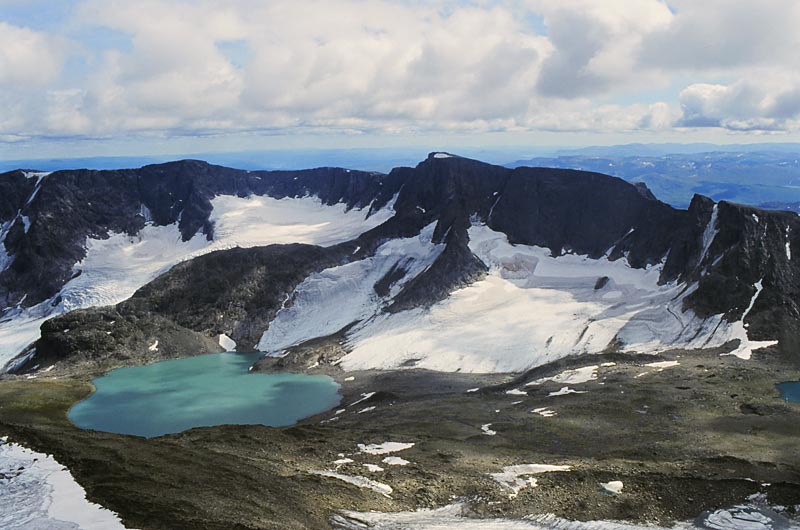
Kalvehøgdi is the highest point of a huge bulky and undulating massif with numerous rounded tops. On the north side of this mountain is a huge impressive escarpment with 400 metre cliffs at the bottom of which are a number of large and crevassed glaciers which flow down into the deep U shaped Leirungsdalen valley. Kalvehøgdi is an excellent ski tour in the spring.
| The Route from Valdresflya Hostel | |
|---|---|
      |
|
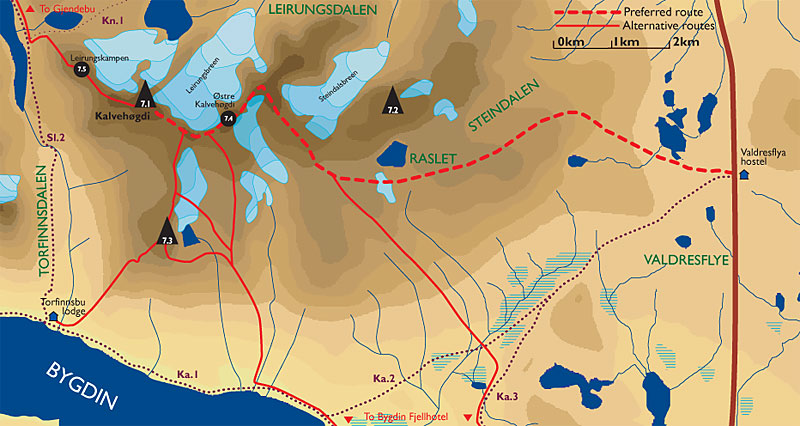 Leave Valdresflya Vandrerhjem hostel and head west across the flat and somewhat boggy plateau of Valdresflye for 2 km passing to the south of the fisketjørni tarns until you reach the lower north end of the stony ridge which descends northwards from this end of the massif. Climb up the stony tundra slopes of the ridge keeping to the north of the small Rasletjernet tarn to gain is rounded crest. Do not go into the boulder strewn Steindalen but head up the ridge rounding the broad knoll at 1854 metres on it northern side. Soon you reach the lip of a large high rocky plateau which in the winter/spring is something of a Shangri-La.
Cross the stony tundra of this plateau weaving through large boulders towards the cliff on the south side of Rasletind. As you go over a gentle rise a small lake fringe with a snowdrift appears. Go round the south side of this lake and continue west for another km. Then start to veer north west towards a broad ridge of more stable boulders. Do not be tempted to head up to early as the slope to the east of this ridge is much looser. After ½ hour of clambering up this bouldery slope the gradient eases and you approach the top of 2088 metres. Continue north west for another ½ hour down through a shallow saddle and up a gentle slope to another top called Mugna at 2159m. As you reach Mugna a spectacular view suddenly bursts upon you. Far below beneath the massive north face lies Leirungsdalen valley and beyond that the Knutshols-Tjønnhols massif rises spectacularly.
Along the escarpment
 From Mugna the route up Kalvehøgdi now follows the edge of the escarpment south west for a km undulating over a few small rises to the peak of Østre Kalvehøgdi. Most of this is very easy but there is a small section where the broad ridge narrows marginally but even on skis this is usually unproblematic.
Descend the slightly steeper south west ridge of Østre Kalvehøgdi for another km to the barely perceptible rise which is Midtre Kalvehøgdi. Along this section there are wonderful views down the north face to the heaving Leirungsbreen glacier. Continue along the escarpment bearing north west now as you start the final climb up to the summit of Vestre Kalvehøgdi. This again is only a simple km and again with the same wonderful views. The final slopes up to the summit are marginally steeper but still quite easy, even on skis.
The Return
The return is by the same route unless you take some of the alternative routes down. The summer only route via Leirungskampen requires some grade III climbing and numerous bits of scrambling. The summer only route via Nordre Kalveholotind and on to Torfinnsbu lodge is much easier but it is difficult to find the correct gully to descend from that mountain. In winter/spring on skis the choice of return is either back down this ascent route to Valdresflye or some of the excellent alternative routes down to Bygdin Fjellhotel lodge depending on if the road is open and where transport is.