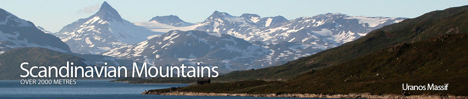
Scandinavian Mountains over 2000 metres - James Baxter
Areas › Uranos Massif › Sagi › Alternative Routes
There are a number of routes up Sagi, some to the north top and some to the south top. The north top is best accessed from the north ridge and the south top is best accessed from the south ridge. The jagged saw-toothed ridge between these two tops is a classic traverse but involves an easy, grade III scramble for about 40 metres, along a very narrow, exposed a and somewhat loose arête.
 This exposed section is the major challenge to parties traversing between the tops and protection is required. In dry summer weather it should not present too big a problem. A description of this traverse is in the main section under the preferred route.
North Summit Route
The main route to the north summit goes up the rugged north ridge from Skogadalsbøen lodge. Leave Skogadalsbøen lodge and head east up Skogadalen valley for 2½ hours through the birch trees and beyond into a basin.
Continue east up out of this basin to a flatter area with a series of tarns on the valley floor just below the base of the craggy buttress of the north ridge of Sagi.
Go just to the east of these crags and then leave the valley and start to head south up the ridge on the ramp above the crags. After an hour across turf and stones the incline eases but the terrain becomes more bouldery. Continue up these boulders for another ½ hour until the ridge becomes more defined, steeper and rocky.
Head up through these outcrops on an increasingly lofty ridge, skirting round a small glacier on the east flank, for a further ½ hour to reach a short steep clamber up to a false top. From this false top continue north down through a small rocky saddle and then up the short final slopes to the north summit.
 The return is by the same route unless you are equipped for the exposed traverse to the south summit. Allow 8-10 hours from Skogadalsbøen lodge return. It is also possible to initially follow the route which goes up beside the Skogadalsbreen glacier to the foot of the south ridge. Then leave this route by the snout of the glacier and traverse up the stony west flank to gain the north ridge.
South Summit from Fondsbu Lodge
The main routes to the south summit involve a glacier crossing up the crevassed Uranosbreen glacier or the very crevassed Mjølkedalsbreen glacier. The former crossing is the preferred route and is described in the main section. The latter is described here.
In addition there are two other routes which also go to the base of the south ridge; one from Skogadalsbøen lodge and then up the side of the Skogadalsbreen glacier to the base of the south ridge and the other over Mjølkedalspiggen to the saddle with Sagi and then to the base of the south ridge.
The route up the Mjølkedalsbreen glacier starts at Fondsbu lodge. It does not cross the Mjølkedøla river but heads north west before this up a small stream and then to the west of the knoll 1306m. It then climbs a small shoulder to reach a series of small lakes.
Follow the west shore of the lakes for 2 km and then the west bank of the river for another 2 km to reach another lake in a moraine wasteland. Continue across boulders for another 2 km on the west of this lake also to reach the snout of the Mjølkedalsbreen glacier.
Ascend the centre of the glacier for a good km to the foot of the ice fall. Then weave up through the jumble of crevasses for a km until the glacier levels off onto a large flat bowl. The crevasses in this icefall are dangerous not only in the summer but also in the winter and a rope should always be used. Once in this glacial bowl continue north west across its vast expanse towards a nunatak, Urdaknatten.
Bear north to the saddle between this curious nunatak and the south flank of Sagi where you can leave the glacier. There is no bergschrund between the glacier and the mountain here. Climb up the boulders here for ¼ hour to the saddle between Sagi and Mjølkedalspiggen and clamber up the south ridge to the summit as described as per the preferred route in the main section below.
Allow 8-10 hours return from Fondsbu lodge depending on conditions through the icefall. route. This route is only for parties with extensive glacial experience.
South Summit from Skogadalsbøen Lodge
It is possible to get to the south top by starting from the north in Skogadalsbøen lodge also.
From the lodge head east up the valley for 2½ hours past the birch forest and into a bowl. Ascend the path out of this bowl for ¼ hour to reach a small tarn. Leave the path and valley hear and start to head south over the small knoll 1276m and on south under the crags into the side valley for ½ hour until your reach the moraine debris at the snout of the Skogadalsbreen glacier.
Head up the debris to the east of the snout and pick your way through boulders and moraine for another ¾ hour on the east side of the glacier until you reach a small stream tumbling down from the saddle between Urdaknatten and Sagi. In the early summer this will be covered in in steep snowfield. Clamber up the somewhat loose boulders and slabs of this slope keeping to the north of the stream to reach a narrow strip of glacier.
Either cross this safe glacial strip or if icy head round its north end and clamber through a rockband to reach the boulder slopes which fan out from the bottom of the south ridge of Sagi. Traverse east up across these boulders to reach the south ridge itself which is then followed to the south summit as described as per the preferred route in the main section below. Allow 7-9 hours return from Skogadalsbøen lodge.
 The Route from Mjølkedalspiggen

The route from Mjølkedalspiggen is commonly used. Descend the very steep 10 metre craggy rampart at the top of the west ridge of Mjølkedalspiggen which is a grade II scramble. Then descend the boulders of the west ridge to the saddle where there is a huge but short block of iron rich rock.
It is perhaps easiest to scramble up the 15 metres onto this block keeping slightly to the north, rather than skirt the boulders and slabs on the south side. On the west side of this block is another saddle and from here the south ridge of Sagi rises steeply. Climb it to the south summit as described in the main section below.
Winter/Spring Ascent
The ascent of Sagi in winter/spring is much simpler because it is easy to ski over the glaciers, however, the final ascent up the 140 metres of the south ridge is quite steep and if icy could be exposed. Thereafter, the traverse of the arête from the south to north top is a serious winter climbing undertaking.
The winter route would start at either Tyinholmen or Fondsbu lodges and follow the marked ski trail to Skogadalsbøen cabin as far as Kvitevatnet lake. From the north end of this lake climb up the bowl for 100 metres of ascent to reach the lake 1506 metres at the edge of the glacier and then follow the summer route as described below.
Mjølkedalsbreen glacier is another possibility but this glacier is much more fractured than Uranosbreen glacier and is not considered as safe in winter or summer.