Scandinavian Mountains over 2000 metres - James Baxter
Areas › Hurrungane › 1.11 Stølsmaradalstind (2026m)
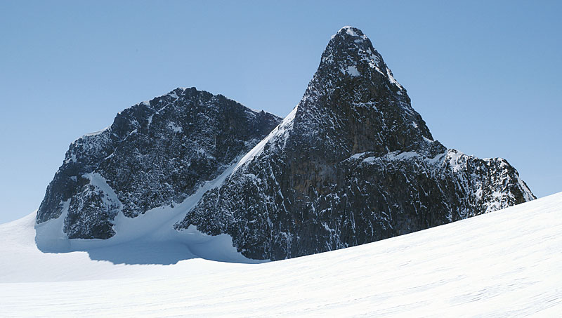
Stølsmaradalstind, 2026m, is a two peak mountain in the more remote southern half of Hurrungane. It lies at the northern end of the long and undulating Stølsmaradals ridge which rises steeply between the U shaped valleys of Stølsmaradalen and Gravdalen. On the north side of the mountain there is a steep arête which drops down to the long Vikingskard saddle before climbing up again to the mountain of Midtre Ringstind.
| The Route from Murane Seter | |
|---|---|
      |
|
The route from Murane is the shortest and easiest. It is essentially a summer route, but it is also possible in the spring, but the final 600 metres up the west ridge is too steep and poorly covered in snow to be plausible to ski, especially when there is such a good alternative from Turtagrø.
Murane Seter
Murane is a old seter, or summer farm, which lies on the east side of the small toll road from Årdal to Turtagrø, about 4 km to the south of the toll booth. Just to the north of the bridge over the Fardalselvi river is a turning to east onto a flat area where there is good parking.
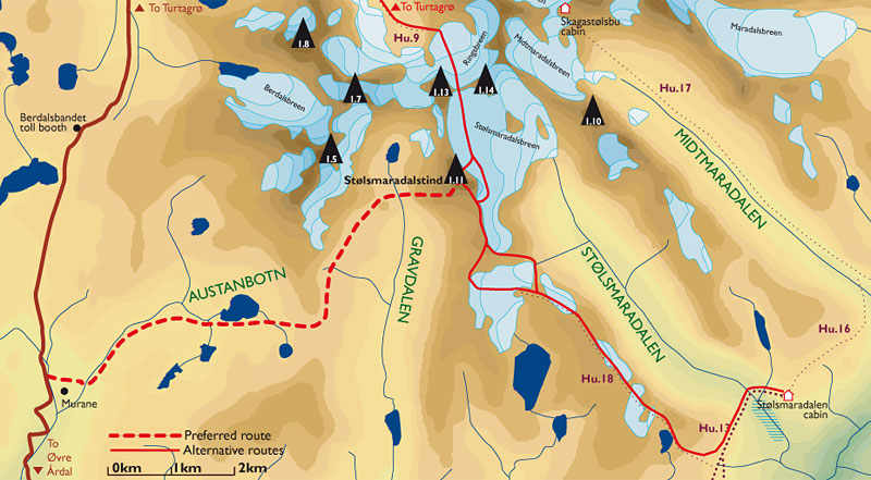 From here pass to the north of the seter houses and over a small spur to reach the lush Austanbotnelvi stream and a wonderful view of Austanbotntind itself. Follow this stream up for a pleasant 2 km crossing over to the east bank, where the going is even easier. This crossing should not be a problem, unless the river is high with snowmelt and rain.
After 2 km the terrain flattens out completely and the stream bed veers east away form Austanbotntind towards a distinct saddle to the south of it. Follow the stream up towards this saddle for a km, crossing a tributary from the south, to get to a small lake, Austanbotnvatnet, 1190m. Continue east passing to the south of this small lake towards the saddle.
Gravdalsbandet Saddle
After the lake the lush pleasant terrain continues as you climb up the gentle grassy slopes for a km to reach the saddle, called Gravdalsbandet. This saddle is still a thoroughfare for reindeer crossing from one valley to another, and there are remains of ancient reindeer pit traps (see Rondane section for explanation) around.
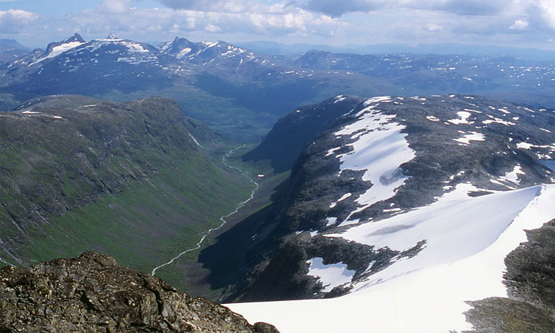
 At Gravdalsbandet the route now heads north east into the upper reaches of Gravdalen for 3 km towards the mountain of Midtre Ringstind. There is a remarkable ⅓ km wide level shelf heading in the same direction along the bottom of the hugely impressive east face of the Austanbotntind massif.
Follow this shelf which is largely mixed grass, rock slab and a few lingering snowfields, especially early in the summer, for the 3 km passing to the west of the small knoll, 1414m, in the valley.
Here the terrain starts to get somewhat awkward as more and more moraine deposits are encountered, remnants from the once mighty glaciers which formed this valley. About ½ km to the south of the lake 1368m, at the end of the Gravdalen valley, there is a substantial moraine deposit. Do not venture onto this but head east along it and cross the small stream that emerges from it, to arrive at the base of the long slope up the west ridge.
West Ridge
This west ridge is more of a slope with a huge precipitous drop down the south side. The slope is not steep at about 25 degrees, but it is a sustained slog up boulders for two 300m sections. The first 300m section initially goes south east, keeping a few hundred metres to the north of the large drop down the south side of the ridge. In the earlier half of summer there is a broad snow filled gully which can easily be ascended, or if the snow is hard and you don't have an ice-axe (you should really always carry one in Scandinavia), clamber up the slab/boulder mix to the north of the gully.
 As you approach the top of this 300m climb the gradient steepens and it is easiest to veer southwards towards the now huge drops down the south side of the ridge, but still keep a healthy distance. There is some easy scrambling through this steeper section to gain gentler ground again at the bottom of the next 300m section.
The final 300m climb now heads north east up a broad ridge, which is covered in boulders. This grind is greatly eased by the ever present very impressive views across Gravdalen below to Austanbotntind and Store Ringstind. It also takes a bit under an hour to ascend this second half and the easiest line to take is straight up the middle of the slope to the saddle between the main summit and the south top. It is only when you approach the top that the view over the majority of Hurrungane suddenly bursts forth and it is very impressive.
From this saddle there is a steep gully that descends down to the huge Stølsmaradalsbreen glacier below, which is sometimes used as an ascent route. There is also a grand view from the saddle down the steep north arête to Vikingskard saddle which is 5 pitches climbing up to grade IV.
From the saddle there is an easy and pleasant 10 minute walk across stable stones to the main summit. The return is by the same route where early in the season some lingering snowfields will ease the descent into Gravdalen. To continue to Turtagrø requires glacial experience and equipment and the descent to Stølsmaradalen cabin is 5 hours long.
