Scandinavian Mountains over 2000 metres - James Baxter
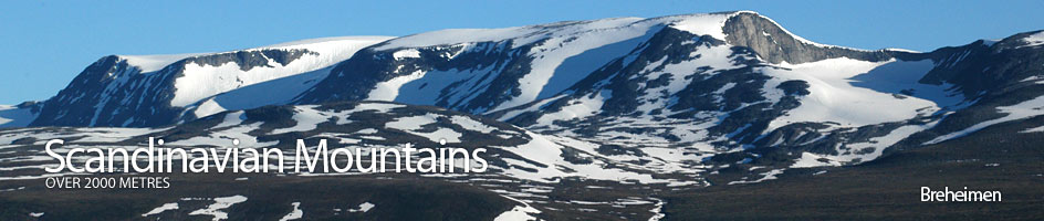
Areas › Breheimen › Detailed Information
Breheimen is a large region with a few mountainous areas within it. One theme which characterizes the whole region are extensive glaciers and icecaps. It is bordered to the north by the Riksveg 15 road between Lom and Stryn which runs up Ottadalen to the watershed before descending steeply to the Nordfjord fjord complex. It is bordered to the south by the Riksveg 55 road between Lom and Sogndal which runs up Bøverdalen to the watershed on Sognefjellsveien before descending steeply to the Sognefjord fjord complex. It is bordered to the west by the deep valleys on the west side of the huge Jostedalsbreen ice cap, the largest glacier by far on mainland Europe.
There are 14 mountains and a further 5 secondary peaks over 2000 metres in the whole region which also has significant glaciation. These mountains can be found in three locations with the Breheimen region. The first of these locations, and the one that contains the lions share of the mountains, is Lundadalen. The second location contains the single and isolated mountain of Tverrådalskyrkja and the third location contain the two nunataks which protrude out of the massive Jostedalsbreen ice cap.
History
Because Breheimen is such a large region it is difficult to generalize about the history of it. There has been hunting throughout the region since pre-historical times and there are animal pit-traps for reindeer, and sometimes moose, throughout the high valleys around Lom. There has been farming communities in the fertile valleys of the fjords and the large valleys around Lom since well before Viking times. Indeed there are some magnificent stavkirke churches which are nearly 1000 years old. With this agriculture there was inevitably some transhumance up to the rich summer pastures in the mountains. Certainly there were summer farms hundreds of years ago in the higher side valleys leading into the mountains from the two main valleys emanating westwards from Lom.
The glaciers in Breheimen have constantly been advancing and retreating through the millennia. Indeed, but studying pollen deposits in lakes scientists believe it is thought that there was virtually no glaciation here at all about 6500 years ago during a warmer period. Then the glacier advance again in the Stone Age about 3500 years ago before retreating significantly in the Viking age about 1000 years ago. Around the mid 18th century there was a mini ice age and the glaciers surged forward to the extent that some farms had to be abandoned, pastures disappeared and there was migration away from the area as land became scarce. During this period the glacier was about twice the size it is today!
There have long been routes over Jostedalsbreen and other glaciers and through the high valleys of Breheimen, not only for trade but also for church and social gatherings. Sometimes even animals were driven over the glaciers and on to markets on the other side. This pretty much ended when the road between Stryn and Lom was completed in 1895. At the end of the 19th century a huge amount of interest was generated in the glaciers and Jostedalsbreen in particular. Slingsby spent time exploring here in the late 1800s and visited the area three times. Simultaneously there was an upsurge in visitors from other parts of Europe and many locals became glacier guides. This tradition has continued until today all around the Jostedalsbreen glacier.
Climate
The climate of Breheimen is very varied. The precipitation around Jostedalsbreen is very high and it is this rather than low temperatures which have given rise to the large glaciers. Further east the winter temperatures get much colder but the precipitation is much less. Indeed in Ottadalen valley around the town of Bismo (Skjåk) there is so much of a rain shadow created by the mountains of Breheimen that irrigation has been used for centuries to make the best of the fertile valley floors.
Access
Access to the area in the winter time is limited due to blocked roads. The road from Lom to Stryn is usually open all winter, but the road from Lom to Sogndal is blocked by drifts in the Sognefjell area. The road between Sogndal and Stryn to the west of Jostedalsbreen is usually open in the winter. However, most of the small roads up the side valleys are blocked until May and it is necessary to ski for a few hours to gain the road ends. In the summer all the roads up the side valleys are open and it is possible to drive up them, usually for a small fee as they are private roads. Due to the high undulating nature of Breheimen it is a superb area to visit in the winter/spring. There are a number of self service cabins in the heart of the region which provide accommodation in summer and winter/spring.
Maps
Because the Breheimen map covers such an extensive area I have divided the map into two halves, western Breheimen and eastern Breheimen with an overlapping section in between. One map can be accessed from the other.