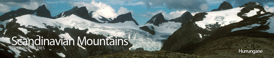
Scandinavian Mountains over 2000 metres - James Baxter
Areas › Hurrungane › 1.5 Austanbotntind (2204m)
Store Austanbotntind, 2204m, dominates the western half of Hurrungane. Its lofty exposed summit, with the 3 characteristic humps, rises some 700m straight above the Gravdalen valley below on the east side. From the summit ridge, the jagged south and west arêtes descend down to the south and west peaks respectively. Around the towering mountain 4 glaciers grind away at its precipitous sides. The biggest of these glaciers, Berdalsbreen, calves icebergs into a lake. I have tried to be objective while writing this guide, but must admit Austanbotntind is my favourite mountain in Scandinavia.
| The Route from Berdalsbandet Tollbooth | |
|---|---|
      |
|
From the parking opportunity on the old road 300m north of the Toll booth on the Turtagrø to Årdal road head south up the gentler slopes to pass two small tarns and gain a view of the knoll 1492 and Store Austanbotntind.
 Head for knoll 1492m passing slightly to the north and continue up the slabs of the rounded ridge in a north east direction to gain the main west ridge itself. This ridge can be followed all the way to a peak at 2020m quite easily with just the occasional easy scrambling section.
Just to the east of this peak is a steep glacier filled gully which descends down to Berdalsbreen on the north side. The descent of this 45 degree gully has become something of a classic ski for the hardcore.
The route from peak 2020m down to the top of the gully is steep and involves a short straight-forward 10m scramble. From the top of the gully the route continues east along the main ridge, with some further easy scrambling to the West Top at about 2100m.
 From the West Top it is now easy to see the route to the main, which looks more daunting than it is from this foreshortened aspect. There is initially a steep 40m drop down to the level saddle. A couple of sections on the descent are very steep for 5m but crampon scratches show the way.
The level saddle is followed for about 200m until a thin blade of rock rises up. This blade is very airy and while it is possible to follow its apex, it is usual to avoid it on the south side by dropping down marginally and then by following a series of vague ledges. These ledges slowly lead up towards the notch between the blade and the 45-50 degree rock/snow slab whose top is the summit ridge itself.
 This notch on the far (east) side of the blade heralds the start of the most difficult section up a slab on the north face. There is a snow patch on the north face which varies in size. In the early summer it will completely cover the slab right to its west edge. As the summer progresses this snowfield will both melt and become icy, but slowly the western edge of the slab becomes exposed.
The route goes up this slab keeping to the western edge for a 30m grade II pitch until the rock becomes broken. If the snowfield encroaches onto this western edge of the slab then ice axe, crampons and protection are necessary.
The second pitch, which is also 30m, now veers slightly to the east (left) and initially follows a 15 cm high edge between 2 slabs for 10 metres. At the top of these 2 slabs there is some small loose scree and this is followed for a couple of metres to the east until firmer rock is reached. This firmer rock can be followed for the remaining 15 metres to the lowest saddle on the summit ridge. The second pitch is grade II in the dry, but becomes grade III in the wet. This saddle is the point where the south ridge route meets the west ridge route.
 From this lower saddle, the summit ridge is followed east for 50m up to the middle hump top, which is quite exposed for the last few metres and could warrant use of the rope again especially in the wet.
From the middle hump to the highest and eastern hump is another 50m which is somewhat easier. However, the from the highest hump there is a little spur of about 10m to the summit. This spur consists of 2 narrow boulders on their edge with a large boulder at the far end on them, upon which is the summit cairn. This spur is extremely exposed and the rope should be used again here.