Scandinavian Mountains over 2000 metres - James Baxter
Areas › Rauddalen Area › 4.7 Austre Rauddalstind (2068m)
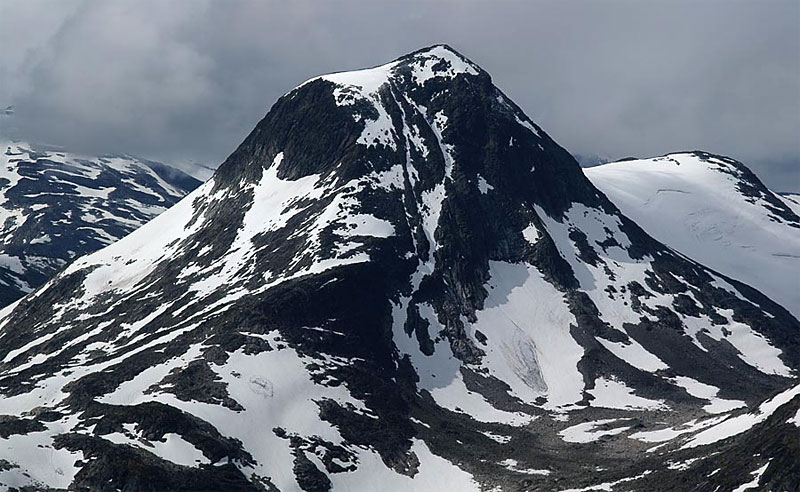
Austre Rauddalstind, 2086 metres, is at the east end of the 8 km long Rauddalstind ridge which contains 3 mountains and rises steeply between Rauddalen and Simledalen valleys. Most of the south flank of the ridge is covered in bare slabs and steep vegetation. On the north side there are 6 glaciers and it is via these glaciers, or the ridges between them, that the routes up the mountains on this long ridge-like massif are found.
| The Route from Olavsbu Cabin | |
|---|---|
      |
|
It is feasible to do all three of the Rauddalstind mountains in a single very long day. For a detailed description of this traverse it is necessary to combine the routes from the pertinent saddles on each of the three Rauddalstind pages.
 After this sustained ascent the terrain becomes steeper again. The grassy shelves become thinner and the outcrops become steeper. It is probably best to veer slightly to the west of the ridge at this point.
Eventually at about 1850 metres you reach a much steeper and somewhat exposed section up a 50-55 degree slope where the rock is almost continuous and interspersed with sparse patches of vegetation and turf clinging to it.
It is now maybe best to veer back to the apex of the ridge again and clamber up this more desperate section. This area is treacherous when wet.
After passing this steep section, the slope eases off again and is covered in boulders for another ¼ hour as you climb up to the flat summit plateau. From here bare rock leads up across shallow slabs for a short distance to the summit cairn.
The Return
The return is by the same route allowing 4-5 hours from Olavsbu cabin. However, if the ascent was precarious and unpleasant the descent is even worse. It is difficult to find the place to begin the steeper section of the descent, and then the descent itself is awkward. In the wet it is unsafe.
 The alternative return to Olavsbu cabin is via the west ridge to the saddle then down into Simledalen valley. This route is the preferred ascent route described in full in the main section.
Follow the route Ra.9 up the valley to the east and go over Simledalsbandet. At Simledalsbandet, which is at 1600m, it is worth keeping to the south and following the 1600m contour round the north east ridge of Austre Rauddalstind until your reach Rauddalsbandet.
Much of this traverse will be on a snowfield. This will save you having to go down to the lake at 1456m and round its north side and then back up to Rauddalsbandet.
From Rauddalsbandet it is 3 km south down the marked path Ra.8 path to Olavsbu cabin. If the return is made via Simledalsbandet the allow 6-7 hours return.
Starting from Leirvassbu Lodge
It is also very feasible to start the main route from Leirvassbu lodge instead of Olavsbu cabin. Leave the lodge and follow the locked track, Ra.1, down Gravdalen valley.
 Then wade the Storutla river to the south side and start to head up Simledalen valley on the route Ra.9.
Either head for the middle of the 3 saddles between Store and Austre Rauddalstind as described on the Store Rauddalstind page.
Alternatively, continue up Simledalen to get to the bottom the spur which leads up to the knoll 1930m on the main ridge as described in the main section below. Allow 8-10 hours return from Leirvassbu lodge.
