Scandinavian Mountains over 2000 metres - James Baxter
Areas › Kebnekaise › Detailed Information
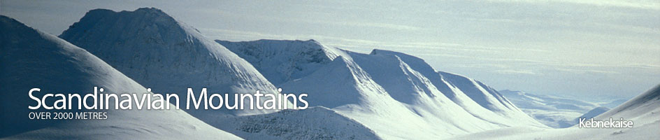
Kebnekaise is the most northerly area with any 2000 metre mountains in Scandinavia and lies well north of the Arctic Circle.
The Kebnekaise massif, along with the adjacent slightly lower Abiskofjällen and Kaitumfjällen massifs, to the north and south respectively make up the greater Kebnekaise Range which is some 100km long and 50km wide.
From the lakes around the massif, especially on the east side, huge birch clad forests with silt laden and meandering rivers lead into the range. Mammoth arterial glaciers would have filled these valleys but they have now retreated up to the high side valleys in the wilder alpine heartland of the range.
To the north of the range is the huge Torneträsk lake and to the south is the equally large Akkajaure lakes with separates this range from the Sarek ranges. To the east are the endless spruce forests on the gentle slopes leading down to the Gulf of Bothnia. To the west is a deep valley called Tjäktjavagge and to the west of this valley is a high plateau dotted with lakes and some mountains before dropping down to the deep coastal fjords in Norway.
The Kebnekaise massif, which is the most alpine massif in the whole Kebnekaise Range, contains three magnificent mountains and a very interesting secondary peak. Glaciation is still very prevalent in the vicinity of these mountains and large glaciers still continue to gnaw into their flanks. In all there are about 50 glaciers here, as opposed to about 100 in Sarek. Indeed the highest mountain Kebnekaise is topped by an ice pyramid. The glaciers flow right down to about 1200 metres- much lower than in Jotunheimen.
Flora and Fauna
Because this range lies so far to the north conditions are even harsher here than in central Norway. The treeline here is only about 700 metres while in Jotunheimen it is about 1000 metres. Boulderfields are more prominent especially in the higher valleys where as a consequence camping can be problematic.
The area is not as wild as Sarek but none the less still has a rich arctic flora and fauna. During the winter most of the fauna either migrates or hibernates under the snow. Only very hardy animals like the wolverine and Arctic fox are active in the winter hunting Ptarmigan and occasional reindeer which have failed migrate to the lowland forests.
However, rather surprisingly it does not enjoy national park status. Recent attempts to create a national park have meet with strong opposition from the local population. As a consequence there is some hunting in the area during the hunting season, which somewhat squanders the regions star attractions like moose, wolverine and lynx. They are hunted for meat or to protect the herds of Reindeer.
Reindeer and the herding culture surrounding them are still very prevalent here. There are various locations on the edge of the Kebnekaise Range which are important summer centres where reindeer are corralled for annual tasks. This has been the case for centuries. There is also a strong fishing culture here in the summer, and in the winter through holes in the ice. Some Sami even manage to put nets out in the winter under the metre thick ice by using preinstalled pulley systems. The main fish in the lakes around in the Kebnekaise Range are Arctic Char.
History
The Kebnekaise area was first explore by cartographers in the late 19 century. Kebnekaise itself was mot climbed until 1883 by the Frenchman Charles Rabot. It was in the early decades of the 20 century that the Kungsleden walking trail in the valley to the west of the Kebnekaise Range was developed and the first rustic lodge built at Kebnekaise Fjällstation 19 km west of the Sami township of Nikkaluokta.
Kungsleden Walking Path
The Kungsleden walking path is a 440 km hiking or skiing path which goes from Abisko to Hamavan. This northern section in the Kebnekaise Range is rather tame and it takes an easy week to complete the section between Abisko and Vakkotavare.
The entire path is marked by garish red crosses and duck boards prevent hikers getting wet feet-; and minimize erosion. There is also a series of cabins along its length. The path distracts from the wilderness experience but at the same time allows other areas retain a more unspoilt nature. It is a sacrificial lamb for those who want to dip their toe into the Swedish outdoors. As the path heads further south it becomes much wilder.
Climate
Like Sarek, the Kebnekaise Range is not renowned for good weather. It is influenced by Atlantic Ocean and Barents Sea low pressure weather systems. However, it is not unusual for high pressure to build bestowing good weather for a week or longer. During the summer it is continual daylight for about 8 weeks and little darkness for about 5 months.
During the winter it is dark for a few weeks and virtually dark for a few months bar a short glow each day. In the winter if the sky is clear there are often marvellous displays of the northern lights or aurora borealis. The temperatures in the summer may climb to 25 centigrade In the endless sunlight, but in the winter may dip to -45 centigrade.
Access
Access to Kebnekaise Range is quite easy throughout the year. The main access points are Nikkaluokta on the east side of the Range. There is a daily bus service connecting this village to the town of Kiruna. From Nikkaluokta there is a 4-6 hour walk or ski to Kebnekaise Fjällstation lodge.
For the environmentally unaware it is also possible take a reasonably cheap 15 minute helicopter shuttle between the Nikkaluokta and the lodge. This is rather indicative of the poor attitude towards the wilderness in this region. There is also good year round access to the north of the Kebnekaise Range at Abisko station. This is on the main railway line between Narvik and Kiruna and eventually Stockholm. From Abisko it is a 3-5 day walk southwards to the base of the 2000 metre mountains on the Kungsleden path.
From the south there is a 3-4 day walk northwards from Vakkotavare to reach these same 2000 metre mountains.