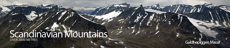
Scandinavian Mountains over 2000 metres - James Baxter
Areas › Galdhøpiggen Massif › 10.3 Vesle Galdhøpiggen (2369m)
Vetlepiggen, 2369 m, is Galdhøpiggen's smaller sibling. However, its is still in its own right the sixth highest mountain in Scandinavia and is of a very alpine nature. It is a sloping plateau with almost entirely vertical sides and nearly completely surrounded by glaciers. There is one chink in its armour and that is the short narrow north east arête.
| The Route from Juvvasshytta Lodge | |
|---|---|
      |
|
From Juvvasshytta lodge follow the well worn path south across the stony plateau on a slight rise to the east of Gjuvvatnet lake. After a km the path forks with a less distinct track heading south east traversing plateau before dropping down to Spiterstulen lodge while the other fork heads south west up the shallow incline towards the obvious summit of Galdhøpiggen. Take the latter fork and follow its well cairned route up across the gentle stone field for three km to the edge of the Styggebreen glacier. This route across the stonefield is well worn and obvious as it is also the easy way up Galdhøpiggen.
 At the edge of the glacier the route up Galdhøpiggen continues to the south west across the ice. The route to Vetlepiggen follows this for 200 metres and then veers west towards the east ridge of Galdhøi which descends into the ice to the south of a small but steep corrie. The ½ km of glacier which is crossed between the north edge of Styggebreen and this ridge is safe and is at a shallow incline, and should not present any problems.
Once on land again at the bottom of the ridge head west along the moraines at the edge of the glacier, under the scree-clad south flank of Galdhøi. The stones here are somewhat unstable and it might be preferable to follow the edge of the ice but beware of any overhangs caused by melting. After a km up an easy incline along the glaciers edge the route approaches the Løyfti saddle. Continue past a small depression sometimes filled with water and the turn south up a 5 metre high moraine ridge. Once on this moraine ridge follow it west for 50 metres to the bottom of the north east arête.
The arête is not as difficult as it looks, but is very exposed on the western side. It just involves easy scrambling for 5 minutes until just before the top. Here the is a two metre step, but there are good holds to help you over the bulge. From the top of this step it is a few more easy metres onto the sloping top plateau.
From the top of the arête there is a fantastic view down to the farms in the Leirdalen valley some 1600 metres below, beyond the snout of the heavily fissured Storgjuvbreen glacier. The summit plateau itself is not steep and it is easy to follow the packed stones along the north ridge over a shoulder to the summit. Here there is of course a magnificent view across the gap to Galdhøpiggen exactly 100 metres higher.
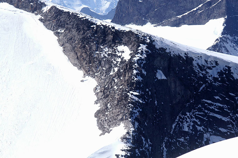 There is an option to avoid this arête by following the edge of the glacier up under its eastern side. This entails climbing quite steeply up the ice (about 35-40 degrees) for about 50 vertical metres to reach a short gully onto the plateau just above the top of the arête. In winter this used to be a common route but the glacier has shrunk away from the wall and the gully is now quite steep. In addition there is often a bergschrund there in the summer.
The return is by the same route. Alternatively from the Løyfti saddle it is easy to climb the stony short ridge to the north and then bear east to reach the summit of Galdhøi. From the saddle this is a quick 15 minutes. From here it is easy to head north east down the broad stony, but stable, ridge to the saddle with Kjelhøi, 2223m. This is very easily climbed from here and is only ½ hour return at the most. Back at the saddle descend down the southern edge of the Veslegjuvbreen glacier to the eyesore of the ski lift station. From there it is only a km along the road to Juvvasshytta lodge. I preferred to give the ski centre and its brutal, rude intrusion into this unique nature a wide berth and descend Kjelhøi via the north side of the very marked Kjelen corrie and the southern edge of the Gjuvfonni glacier. Keep a good distance from the edge of Kjelen corrie in the spring and early summer as the cornices are huge here. This is the reverse of the route to take if you are not confident about crossing the small ½ km section of the Styggebreen glacier from the north edge to the east ridge of Galdhøi if ascending Vetlepiggen.
If you are familiar with glaciers and have the equipment it is possible to descend to Løyfti saddle and then head south east for a km to reach the bottom of the ridge north east ridge up Galdhøpiggen and climb this mountain. This would only add another 2 hours onto a short day and more details are on the Galdhopiggen page.