Scandinavian Mountains over 2000 metres - James Baxter
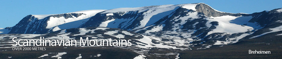
Areas › Breheimen › 15.6 Lodalskapå (2083m)
Lodalskåpa, 2083m, is a proud and majestic nunatak which has withstood some 40 ice ages over the last two million years. During these ice ages the glaciers, have completely surrounded her in ice but never totally covered her, much as it does today. This ice has flowed round her sides gnawing away at her flanks and then flowing down into deep valleys, but she has always kept her steep crown above the ice.
Lodalskåpa, is one of the very finest mountains in the book. Due to its westerly location it does not enjoy stable weather. It is not a mountain to contemplate if the forecast is anything but good. However, the ascent of Lodalskåpa during stable weather is an unforgettable and magical experience.
| The Route from Bødalsæter Cabin | |
|---|---|
      |
|
Leave Bødalsæter and head south west for 400m to reach the bridge over the icy Bødalselva river. Once over head upstream on the west bank for two km on a good path through birch forest until you get to a concrete bridge over the glacial stream from Bødalsbreen glacier.
After the bridge the path continues along the south of the river for another gentle km, crossing a smaller bridge, before it starts to climb towards the small waterfall riddled cliff, called Fessene. During the km climb the path is much more rugged and in some place quite steep as it weaves up through the birches, immediately to the south of the main waterfall, and to the north of another stream. At the top of the Fessene cliff the path emerges from the remaining birch onto a flat valley floor.
 Continue west into the valley on a clear path between the two streams. Ahead the valley curves round to the south into a steep glacier rimmed bowl. As the valley swings south a long mixed stone and grass slope rises out of the valley floor 1½ km straight ahead in the east.
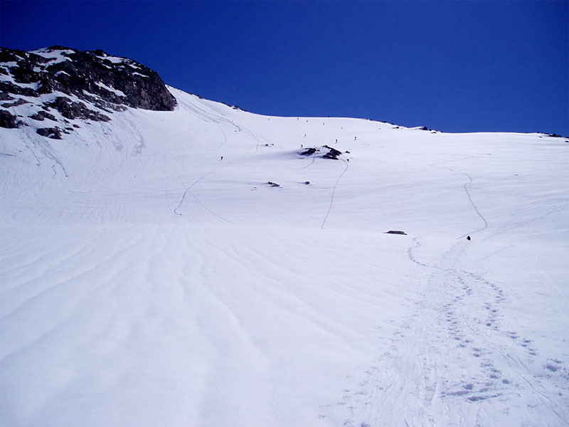
This is Brattebakken, a relentless 700 metre ascent right up to the edge of Bohrsbreen glacier. Follow the path along the pleasant valley to the bottom of Brattebakken and start to climb.
The path becomes much rougher and less pronounced as it climbs steeply. After climbing for an hour the path veers south passing to the south of the knoll 1331m. If you divert briefly to the knoll you will have a glorious first view of Lodalskåpa.
From the knoll the path continues to climb steeply for another hour. The glaciated bowl to the south becomes more spectacular as you climb. At the top of the second half of the climb there will often be snowfields and this can make the arduous ascent even harder. Not before time the gradient at last starts to ease as the top of the climb is reached. As you approach the top veer east to gain a rock outcrop. On top of this outcrop is a large cairn. It is important to locate this cairn on the return as it marks the top of Brattebakken and the descent route.
During the winter and spring the snow up the first section of Brattebakken is steep and occasionally avalanche prone. To avoid this danger and enjoy a more pleasant ascent do not go straight up Brattebakken. Instead veer north east and follow the southern bank of the stream which tumbles down from Kåpevatnet lake. There is no path but it is easy to pick a route through the crags, along as you do not stray too far onto the ridge to the south.
 After a km the river from Kåpevatnet emerges form a broad shallow gully. Enter this gully which, should be entirely snow-filled, and it will lead you up to the outflow of the lake. The last 20 metres may be steep. Once at the lake there is a gentle climb up to knoll 1331m. Do not go to the knoll, but pass 200 m to its east while going south and still climbing and then enter Brattebakken higher up leaving you with only the final 200 metres to climb.
At the top of Brattebakken and the cairn you arrive at the edge of Bohrsbreen glacier. While this is considered a safe glacier there are some crevasses and deep ravines from surface streams and in the summer time a rope is essential. From the cairn head south east for a km across the almost flat glacier towards the moraines at the bottom of west ridge which descends from Lodalskåpa and Veslekåpa. This lies ½ km north of Ståleskardet saddle which cannot be seen from here. Just before you reach the bottom of the west ridge you descend slightly.
The first 50 metres of ascent up the west ridge are up across scree and stones. This unpleasant terrain is luckily short lived and the gradient soon eases out as you reach a smaller glacier. Keep to the north side of this small glacier and head onto the rocky ridge which curve round slowly to the east as it slowly ascends up to Veslekåpa. In the spring zigzag up the steeper slope and when you gain this small glacier and follow it up keeping in the northern half.
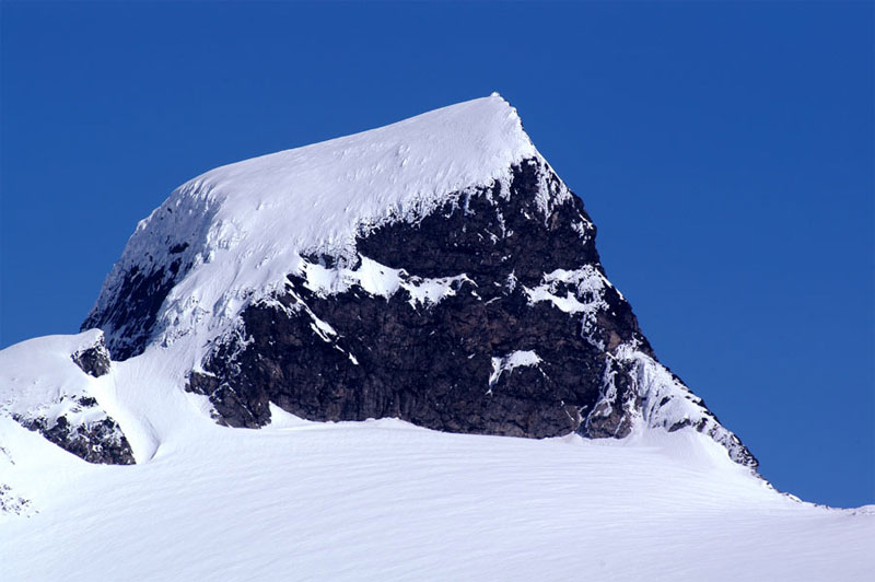
As you approach the top of Veslekåpa there is a small shallow but ice filled saddle to cross and then a icy ridge to the top. From the top of Veslekåpa there is a somewhat exposed snow or ice ridge to descend for 20 metres until the ridge broadens out into a small saddle at the foot of Lodalskåpa itself. The ridge from the saddle, the south west ridge, of the crown itself involves a couple of grade IV pitches. Our route, the easiest ascent route now traverses across the top of the glacier on the western face towards the north west ridge where there is a marked notch called Hanken. In the spring it is best to traverse to south east of Veslekåpa to avoid the descent down the somewhat exposed ridge to the saddle with Lodalskåpa, but beware of a bergschrund here.
 From Hanken notch the final ascent begins. It is very steep about 50 degrees for 60 vertical metres and then 30 degrees for the remaining 50 vertical metres. The lower steep section is up rock in a very open gully. Most of the looses stone here have been dislodged over the years and the remainder are stable. During the spring and early summer much of this is covered in snow, often icy, and ice axe and crampons are essential. In fact there can be snow here at any time of year. A rope could also be useful on this lower section.
The return is by the same route. The descent down the steep section will be harder than the ascent, especially if covered in snow. If the weather turns bad it will be difficult to find the cairn marking the start of the descent down Brattebakken, but it is imperative to do so as there is no other safe way down. It is also possible to continue to Fåbergstølen via the alternative ascent route mentioned above but this is a very long day and if the Småttene icefall is difficult or impassable untold problems could evolve.
It is very feasible, especially in spring on skis to ascent the mountain of Brenibba before returning to Bødalsæter. In this case return down the west ridge of the massif until you are back on Bohrsbreen glacier. Then head south for a km climbing gradually up to Ståleskardet saddle. From this saddle continue as described on the Brenibba page. If you are returning via Brenibba add three hours in the winter and four in the summer. There is also some return routes from Brenibba to Fåbergstølen in Jostedalen which avoid Småttene icefall, and these are worth considering if you want to traverse the Jostedalsbreen ice sheet, but these are long (see Brenibba for further details).
