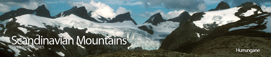
Scandinavian Mountains over 2000 metres - James Baxter
Areas › Hurrungane › Walking Routes › Hu.18
| Hu.18 | Turtagrø hotel to Stølmaradalen cabin |
|---|---|
| 11 hours / 24km 1140m |
Route across glaciers. Suitable for experienced mountaineers only. |
Leave Turtagrø hotel and walk along the road to Øvre Årdal for 2km and then take the path up Ringsdalen valley (Hu.9). Follow the good path up the valley floor on the east side of the stream for 3km, and then continue for another 1km across boulders to a small lake. From the lake pick a way through the moraine in the direction of Midtre Ringstinden for 1km.
Then start to ascend the steeper scree slope on the east to reach a snowfield under a rock band. Climb the snowfield and scramble up through the rock band to gain a flatter moraine area which is followed south east for ½km to the edge of the glacier. This is a crevassed glacier and crampons, an ice axe, rope and experience are essential. Ascend the glacier for 1km in a southerly direction to reach the Ringsskard pass. See Østre Ringstind for further details.
From Ringsskard pass continue south onto the larger Stølsmaradalsbreen glacier and cross it in a south direction for 2½km, keeping close under the impressive spire of Stølsmaradalstinden to reach its south ridge.
Leave the glacier here and climb a knoll (1787m) to the south. Descend this knoll to the southern saddle and then cross the glacier to the east in a due east direction for 1km. From the east side of this glacier a line of cairns follows the crest of a 4km undulating ridge to the south east. Follow this pleasant ridge and after passing well to the north of a tarn begin a poorly marked steep descent down the hillside, keeping on the north side of a growing stream. At the bottom of this steep slope the path from Avdalen Farm to Stølsmaradalen cabin (Hu.13) is met. It is only 1km to the latter. For more details on the descent from Stølsmaradalsbreen glacier see the Stølsmaradalstind alternative routes.