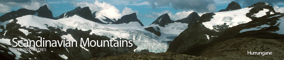
Scandinavian Mountains over 2000 metres - James Baxter
Areas › Hurrungane › Soleibotntind › Alternative Routes
The west ridge is the only simple way up Store Soleibotntind and it is described below in detail in the main section. There are two much more difficult routes also, one up the north ridge which involves some difficult scrambling/easy climbing and the route up the south east ridge which involves a glacier crossing and some difficult scrambling.
 These two more difficult routes are only really feasible in mid to late summer (July-mid Sept). The route up the north ridge was also the route of the first ascent in 1888. The two routes, up the north and south east ridges, can be combined to give a classic traverse which is likely to take experienced parties 10 hours in good conditions. The traverse can always be cut short at the half way point by descending the easy west ridge.
The North Ridge Route
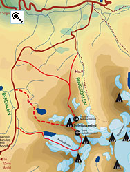
For the north ridge it is probably best to start at Berdalsfjellet some 8 km from Turtagrø hotel on the Turtagrø-Årdal road. It is also possible to start a from the same road at the turn off up Ringsdalen which is just 3 km from Turtagrø hotel.
Whichever starting point the first objective is the knoll of Lauvnosi, 1482m, on the north ridge of Lauvnostind and Soleibotntind. Lauvnosi is 2½ km to the east or south of the 2 starting points respectively.
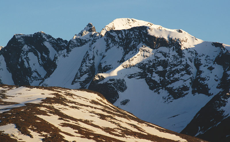
From Lauvnosi follow the ridge up heading over to the east side where there is a great view down into Ringsdalen and the mountains beyond. After an easy 2 km the ridge starts to narrow considerably, with airy drops on each side for the final ½km to Lauvnostind, 1965m. After Lauvnostind the narrow ridge drops to the saddle with Nordre Soleibotntind.
About 30 metres before the saddle there is a gully to the west with an awkward chock stone in it. Descend this grade III gully, clambering over the chock stone, and continue down the steep, short, loose gully to a shelf. Follow this shelf north round a difficult corner to reach the saddle. From this saddle Nordre Soleibotntind can be climbed up the north arête but this involves a pitch of grade V. It is possible to avoid this by skirting round to the west side of the peak.
At the bottom of the crag a sloping shelf leads off south. Follow this for 100 metres until you are at the bottom of a wide, and probably snow-filled, gully. This short gully, which is 35 degrees, may also be icy and crampons are essential, if not a rope also. The top of this snow gully is at the saddle between Nordre and Store Soleibotntind. Nordre Soleibotntind can be ascended from here by its southwest arête (see associated peaks for details). From the saddle scramble along and up the craggy exposed arête for 300 metres to Store Soleibotntind, avoiding a couple of steps on the north west side.
It takes about 5 hours from Berdalsfjellet to the summit. Add 1½ hours if Nordre Soleibotntind is included also. Descend via the easy west ridge (3 hrs extra) or complete the classic traverse by continuing to down the south east ridge as described immediately below (5 hrs extra).
 The South East Ridge Route

For the south east ridge it is best to start from the Turtagrø-Årdal road about 2 km south of the bridge over the Berdalselvi river. Parking is difficult but there are a few spots. From the road make for the glacial lake at the bottom of the Berdalsbreen glacier. Go onto the glacier well to the south of this lake and start to climb up towards Ramnaskard saddle to the east.
This glacier is crevassed and glacial experience and equipment are essential. As you approach the pass the gradient steepens a lot. From the Ramnaskard saddle now head north across rocks to the small detached higher section of Berdalsbreen. Continue north across this small glacier traversing up towards Soleiskard saddle between Soleibotntind and the sheer wall of Store Ringstind on the east of the saddle.
From the saddle head north west up the arête for about 50 metres then leave the arête on the west side and continue up across loose scree for another 100 meters until you are to the east of a snowfield. Clamber up the loose rock on the eastern edge of this snow field. As you approach the top of the snowfield, traverse across it to the western side and then continue up across the rock to a knoll on the south end of the south east ridge itself.
From here the 200 metre arête to Søre Soleibotntind is airy but quite straightforward. From here the arête north west is quite straightforward scrambling for 150 where there is a crag. This is avoided on the west side as there are vast drops on the east side. From this crag the straightforward scrambling resumes for another 300 metres past a small saddle and up to a small peak. From this small peak go back south east slightly and scramble down quite steeply on the west side (grade II), for a few metres, to gain a shelf. Follow this shelf north west under the small peak for 30 metres until you reach a prominent long snow gully descending all the way to the glacier. Climb up this gully for 20 metres to reach the saddle being aware of any lingering cornice.
From this saddle clamber up the steep slope of loose stones, with you back to the small peak, to gain the rounded summit dome. Once you are on the summit dome veer north for 300 meters across stones to the summit itself. It takes about 5 hours from the road to the summit. Descend via the easy west ridge (3 hrs extra) or complete the classic traverse by continuing down the north ridge as described above (4 hrs extra, or 5½ including Nordre Soleibotntind).